Disclaimer:
The authors are solely responsible for the content of this report. Material included herein does not represent the opinion of the European Community, and the European Community is not responsible for any use that might be made of it.
Back to overview measures
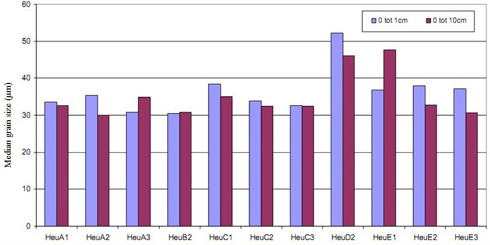
The median grain size is rather constant in the entire area with size 30-40 µm (based on the autumn data from 2009, Figure 3). Only at locations HeuD2 and HeuE1, the median grain size is > 40 µm in one or both samples types (upper soil layer and deep soil layer). In general, the deeper layer (0-10cm) is a little more refined in 8 of 11 sample locations compared to the upper layer (0-1cm).
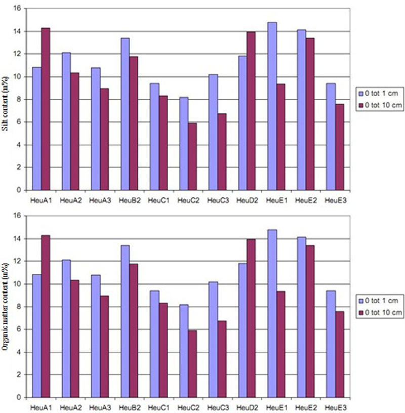
The silt content corresponds to the median grain size: silt content is low if median grain size is large. The silt content is rather constant at all locations and at upper and deep soil layer (Figure 4-left).
The organic matter content varies a little more and is the lowest at locations without vegetation development (HeuC2 and HeuC3, Fout! Verwijzingsbron niet gevonden.-right).
The quality of the recently disposed material was comparable with that of adjacent areas outside the dike.
Benthic density and biomass show a continual increase from year to year at most locations except for locations HeuC1 and HeuC3 (Figure 5). At both locations, the values were of the highest in 2006 but decreased in the following years. This is probably the consequence of a quick initial colonisation (both located near the in- and outlet), followed by a decrease as mud became vegetated.
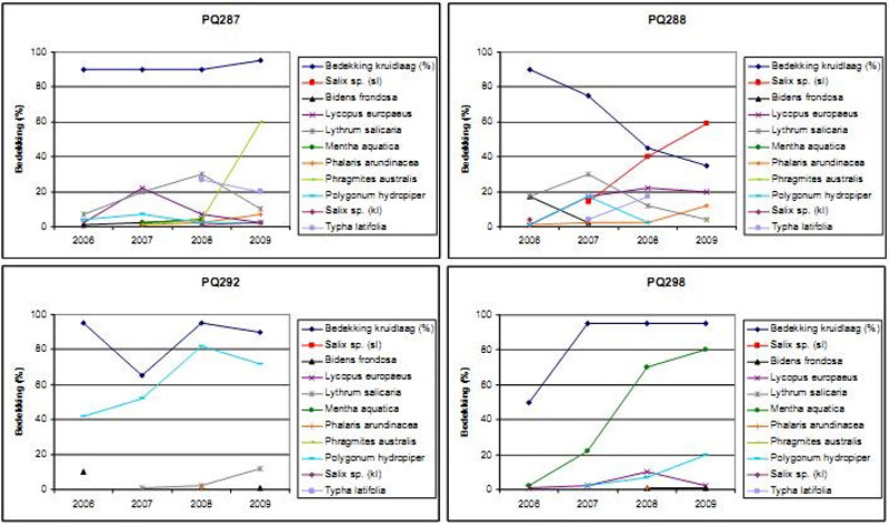
The background of the area was responsible for a divergent succession (Figure 6 & Figure 7). Areas with willows developed further to willow bush with limited ground layer (eg. PQ288). Areas where no willows were settled developed depending on the elevation and corresponding hydrological regime. The lower elevated zones (eg. PQ292) developed with pioneer vegetation such as Water-pepper (Polygonum hydropiper). Also in PQ286 a similar pioneer vegetation of Water-pepper and Beggar Ticks (Bidens frondosa) developed but evolved rapidly to Reed vegetation (Phragmites australis).
The higher elevated zones (eg. PQ299 and PQ298 with less frequent floods but nevertheless wet) developed with a diverse helophyte community, dominated by Watermint (Mentha aquatica) with also pioneer species like Water-pepper (Polygonum hydropiper), Beggar Ticks (Bidens frondosa) and Gipsywort (Lycopus europaeus).
In the lower elevated parts (eg. PQ288), the restoration of the area was responsible for a reverse succession. This happened because the willow bush, traditional climax vegetation at freshwater marshes and therefore present at the higher elevated parts of the marsh, is in Heusden LO present at the lower elevated parts (C transect, eg. location 292). Typical for this area are the high sedimentation rate and the limited drainage, responsible for limited presence of ground layer. Willow bush survived, but poplars (Populus x canadensis) died systematically and the ground layer evolved from Brambles (Rubus sp.) to reed land.
Because of a dike breach during the construction (spring 2006), this area was flooded during a short time resulting in extinction of existing vegetation and sedimentation with a fine mud layer. During the summer of 2006, highly diverse pioneer vegetation developed on this fine mud layer with different species from the Goosefoot- and Dock family (Chenopodiaceae and Polygonaceae). Also different willows developed on this dry bare mud. Since the autumn of 2006, this area was definitely under tidal influence.
Back to top
Heusden LO wetland - small scale tidal wetland restoration in the freshwater zone of the Sea Scheldt
Table of content
- 1. Description of measure
- 1a. Measure description
- 1b. Monitoring
- 1c. Monitoring results
- 2. Execution of main effectiveness criteria
- 2a. Effectiveness according to development targets of measure
- 2b. Impact on ecosystem services
- 2c. Degree of synergistic effects and conflicts according to uses
- 3. Additional evaluation criteria in view of EU environmental law
- 3a. Degree of synergistic effects and conflicts according to WFD aims
- 3b. Degree of synergistic effects and conflicts according to Natura 2000 aims
- 4. Crux of the matter
- 5. References
Additional information
for this measure:
No further information available.
for this measure:
No further information available.
Monitoring results
Topography and geomorphology
Sedimentation in the entire area was about 10cm during the monitoring program 2006-2009 (Speybroeck et al. 2011). The sedimentation is strongly related to elevation and therefore also with flood frequency and flood duration. Hence, sedimentation is stronger in the lower parts (transect C, sedimentation up to 30cm) and lower at the elevated parts. At transect A, even erosion occurred up to -10cm.Sediment characteristics
In an initial phase after completion, the median grain size and corresponding silt content and organic matter content was highly variable. This initial phase was followed by a decrease in median grain size (refinement to type “silt”) and parallel a small increase in silt content and organic matter content.The median grain size is rather constant in the entire area with size 30-40 µm (based on the autumn data from 2009, Figure 3). Only at locations HeuD2 and HeuE1, the median grain size is > 40 µm in one or both samples types (upper soil layer and deep soil layer). In general, the deeper layer (0-10cm) is a little more refined in 8 of 11 sample locations compared to the upper layer (0-1cm).
The silt content corresponds to the median grain size: silt content is low if median grain size is large. The silt content is rather constant at all locations and at upper and deep soil layer (Figure 4-left).
The organic matter content varies a little more and is the lowest at locations without vegetation development (HeuC2 and HeuC3, Fout! Verwijzingsbron niet gevonden.-right).
Sediment quality
The global sediment quality is constant in the area with Triad score 3 “medium contaminated compared to the reference.” With the restoration work, the concentration of some heavy metals decreased (chrome and lead) while the concentration of some organic contaminants increased (PAHs, PCBs, nonpolar hydrocarbon) (Speybroeck et al. 2011). An explanation for this effect is that the recently deposited sediment showed significantly higher concentrations of organic contaminants (cadmium, nonpolar hydrocarbon, OCP, PCBs and PAHs) whilst the original soil was more contaminated with heavy metals (chrome, copper and nickel) (Van den Neucker et al. 2007).The quality of the recently disposed material was comparable with that of adjacent areas outside the dike.
Macrobenthos
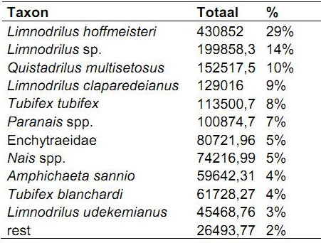
The benthic fauna at the Heusden LO wetland is strongly dominated by Oligochaeta of which 60% Tubificides without hair and 16% Tubificides with hair. Other taxa of Oligochaeta are mainly dominated by the opportunistic species of the Limnodrilus genus (Table 1). Both the Limnodrilus hoffmeisteri and the Tubifex tubifex are known for (heavily) eutrophic substrates. Further, the diversity in Oligochaeta fauna gives an indication of some local evolutions. At HeuB2, for example, the community of pioneer marsh-taxa changed to fauna with only taxa typical for more developed marshes.Benthic density and biomass show a continual increase from year to year at most locations except for locations HeuC1 and HeuC3 (Figure 5). At both locations, the values were of the highest in 2006 but decreased in the following years. This is probably the consequence of a quick initial colonisation (both located near the in- and outlet), followed by a decrease as mud became vegetated.
Vegetation
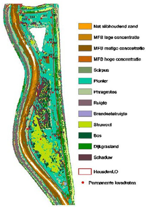
The vegetation development in the area is mainly determined by the prior land use types. The higher elevated parts were used as grassland and cropland, while lower elevated parts were forested.The background of the area was responsible for a divergent succession (Figure 6 & Figure 7). Areas with willows developed further to willow bush with limited ground layer (eg. PQ288). Areas where no willows were settled developed depending on the elevation and corresponding hydrological regime. The lower elevated zones (eg. PQ292) developed with pioneer vegetation such as Water-pepper (Polygonum hydropiper). Also in PQ286 a similar pioneer vegetation of Water-pepper and Beggar Ticks (Bidens frondosa) developed but evolved rapidly to Reed vegetation (Phragmites australis).
The higher elevated zones (eg. PQ299 and PQ298 with less frequent floods but nevertheless wet) developed with a diverse helophyte community, dominated by Watermint (Mentha aquatica) with also pioneer species like Water-pepper (Polygonum hydropiper), Beggar Ticks (Bidens frondosa) and Gipsywort (Lycopus europaeus).
In the lower elevated parts (eg. PQ288), the restoration of the area was responsible for a reverse succession. This happened because the willow bush, traditional climax vegetation at freshwater marshes and therefore present at the higher elevated parts of the marsh, is in Heusden LO present at the lower elevated parts (C transect, eg. location 292). Typical for this area are the high sedimentation rate and the limited drainage, responsible for limited presence of ground layer. Willow bush survived, but poplars (Populus x canadensis) died systematically and the ground layer evolved from Brambles (Rubus sp.) to reed land.
Because of a dike breach during the construction (spring 2006), this area was flooded during a short time resulting in extinction of existing vegetation and sedimentation with a fine mud layer. During the summer of 2006, highly diverse pioneer vegetation developed on this fine mud layer with different species from the Goosefoot- and Dock family (Chenopodiaceae and Polygonaceae). Also different willows developed on this dry bare mud. Since the autumn of 2006, this area was definitely under tidal influence.