Disclaimer:
The authors are solely responsible for the content of this report. Material included herein does not represent the opinion of the European Community, and the European Community is not responsible for any use that might be made of it.
Back to overview measures
The Wetlands contain a variety of coastal habitat types and is designated as part of the SPA because it provides key functional habitat as a high tide roost for significant numbers of overwintering and migratory coastal wading birds, whilst also providing breeding grounds for little terns, a rare species with an endangered population at this site.
A study into the impact of coastal erosion at the Wetlands predicts that the barrier beach will recede, squeezing the Wetlands and the sand and shingle ridge against the line of the coastal flood defence. The study predicts that the habitats that support the internationally important coastal bird population found at the site will gradually deteriorate and will be lost within 30 years.
The Kilnsea Wetlands project was driven by the Humber Flood Risk Management Strategy (Humber FRMS) and associated Shoreline Management Plans (SMPs). The Humber Flood Risk Management Strategy and subsequent studies have set out the immediate need to provide replacement habitat for the coastal erosion losses at the Wetlands. The replacement fulfills a legal obligation under the Habitats Directive, as set out in Defra policy, to provide suitable habitat for critically endangered little terns at the site. It also meets Environment Agency Outcome Measure 4 targets by bringing 70ha of The Wetlands SSSI back into favourable condition, as well as providing 43ha of functional replacement coastal wetland habitat. Table 1 displays a summary of habitat creation and improvement measures by field compartment. The scheme also contributed to national and regional outcome Measure 5 targets through the creation of BAP habitat within minimal additional cost.
Table 1: Summary of habitat creation and improvement measures by field compartment
Back to top
Kilnsea Wetlands
Table of content
- 1. Measure description
- 1a. Description of the issue and measure
- 1b. Status of the measure
- 1c. Habitat Creation Area Discription
- 1d. Monitoring
- 2. Execution of main effectiveness criteria
- 2a. Impact on ecosystem services
- 2b. Degree of synergistic effects and conflicts according to uses
- 3. Additional evaluation criteria in view of EU environmental law
- 3a. Degree of synergistic effects and conflicts according to WFD aims
- 3b. Degree of synergistic effects according to Natura 2000 aims
- 4. Crux of the matter
Description of the issue and measure
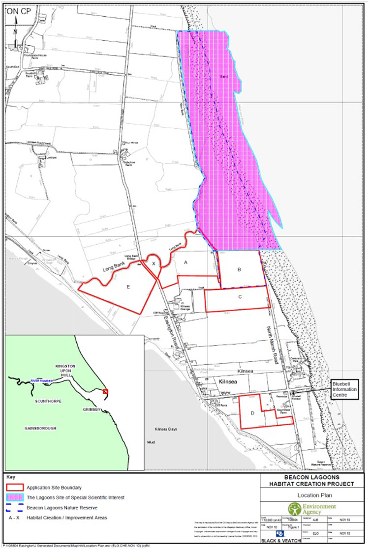
The Kilnsea Wetlands (the Wetlands) Site of Special Scientific Interest (SSSI) forms a constituent part of the Humber Estuary Special Protection Area (SPA) and Ramsar site and is located on a section of the rapidly eroding coastline on the Spurn Peninsula, between the villages of Easington, to the north, and Kilnsea, to the south (See Figure 1).The Wetlands contain a variety of coastal habitat types and is designated as part of the SPA because it provides key functional habitat as a high tide roost for significant numbers of overwintering and migratory coastal wading birds, whilst also providing breeding grounds for little terns, a rare species with an endangered population at this site.
A study into the impact of coastal erosion at the Wetlands predicts that the barrier beach will recede, squeezing the Wetlands and the sand and shingle ridge against the line of the coastal flood defence. The study predicts that the habitats that support the internationally important coastal bird population found at the site will gradually deteriorate and will be lost within 30 years.
The Kilnsea Wetlands project was driven by the Humber Flood Risk Management Strategy (Humber FRMS) and associated Shoreline Management Plans (SMPs). The Humber Flood Risk Management Strategy and subsequent studies have set out the immediate need to provide replacement habitat for the coastal erosion losses at the Wetlands. The replacement fulfills a legal obligation under the Habitats Directive, as set out in Defra policy, to provide suitable habitat for critically endangered little terns at the site. It also meets Environment Agency Outcome Measure 4 targets by bringing 70ha of The Wetlands SSSI back into favourable condition, as well as providing 43ha of functional replacement coastal wetland habitat. Table 1 displays a summary of habitat creation and improvement measures by field compartment. The scheme also contributed to national and regional outcome Measure 5 targets through the creation of BAP habitat within minimal additional cost.
Table 1: Summary of habitat creation and improvement measures by field compartment
| Area | Target Habitat Type | Habitat Are (ha) | Works Required |
| A | Freshwater scrapes & islands | 7.4 | Land forming to create water bodies Water level control structures (low level weirs) Break & block field drains Screen sources of disturbance with 1.5m high earth field bunds. |
| Wet grassland with seasonal scrapes |
3.3 | ||
| B | Saline scrapes, lagoons and islands |
5.1 | Lower sections of the redundant internal field bund to increase connection to the Wetlands. |
| Wet grassland with seasonal scrapes |
1.2 | Break & block field drains Excavation to create ditches and foot drains Land forming to create scrapes |
|
| C | Saline scrapes | 1.9 | Break & block field drains Land forming to create scrapes |
| Wet grassland with seasonal scrapes |
5.8 | ||
| D | Wet grassland with seasonal scrapes |
5.8 | |
| E | Wet grassland with seasonal scrapes |
11.6 | |
| X | Wet grassland and pond | 0.9 | Excavation to create dipping pond (Reduce disturbance from Provision of new parking area) |