Disclaimer:
The authors are solely responsible for the content of this report. Material included herein does not represent the opinion of the European Community, and the European Community is not responsible for any use that might be made of it.
Back to overview measures
This area was surrounded by two dikes: winter- and summer dike. The winter dike (from the north to the south) was elevated and broadened (Sigma height and -width). The summer dike (central zone D-E) was partly excavated.
Table 1. Description of the 7 zones of the Ketenisse marsh (Van den Neucker et al. 2007).
Analysis of the evolution after restoration fits in with the decisions about the Development outline 2010 and Long Term Vision 2030 (Dutch and Flemish agreement on integrating accessibility, naturalness and flood safety) and the updated Sigmaplan (Flemish plan for flood protection combined with ecological objectives), of the Dutch and Flemish governments, that committed them to leap forward with the ecological rehabilitation of the Scheldt estuary. An important challenge is the creation of tidal wetlands by transformation of woods or agricultural land into tidal mudflats and marshes. In order to assess the feasibility and to identify possible problems any similar small scale projects already in place, such as Ketenisse, are studied in detail to improve our apprehension of the larger scale future plans.
Back to top
Ketenisse wetland - small scale tidal wetland restoration in the brackish part of the estuary
Table of content
- 1. Description of measure
- 1a. Measure description
- 1b. Monitoring
- 1c. Monitoring results
- 2. Execution of main effectiveness criteria
- 2a. Effectiveness according to development targets of measure
- 2b. Impact on ecosystem services
- 2c. Degree of synergistic effects and conflicts according to uses
- 3. Additional evaluation criteria in view of EU environmental law
- 3a. Degree of synergistic effects and conflicts according to WFD aims
- 3b. Degree of synergistic effects and conflicts according to Natura 2000 aims
- 4. Crux of the matter
- 5. References
Additional information
for this measure:
No further information available.
for this measure:
No further information available.
Measure description
The Ketenisse marsh is located in an industrial area at the left bank of the Lower Sea Scheldt (along 4km of the river), between the fortress of Liefkenshoek and the Kallo sluice (Van den Neucker et al. 2007, Speybroeck et al. 2011). The objective was to restore processes that lead to the development of a brackish tidal wetland. The restoration was a compensation for the North Sea Container Terminal on a mudflat in 1994-1995 in the Port of Antwerp. To restore the tidal wetland, the area was separated from the inland by the construction of a new dike with Sigma height (at the site of the old winter dike) and the area itself was lowered back slightly under Mean High Water level (embanked as a polder in second half 1800s and over the years elevated mainly with specie from construction works in second half 1900s). The plan was to remove the rubble of the summer dike and the dumped material and to level the area with a weak slope below mean high water level, creating the optimal starting conditions for new intertidal mudflats and marshes (60 ha, of which 35.5 ha restored). Some parts have however not been lowered as planned, resulting in large variation in height and slope leaving supratidal vegetated parts, lower bare mud and a rather steep slope along the summer dike remnants. The total area can be divided in several zones with different historical and starting situation (LHT, ABC, D, E, F, G; Table 1 & Figure 4).This area was surrounded by two dikes: winter- and summer dike. The winter dike (from the north to the south) was elevated and broadened (Sigma height and -width). The summer dike (central zone D-E) was partly excavated.
Table 1. Description of the 7 zones of the Ketenisse marsh (Van den Neucker et al. 2007).
| Zone | Description: history and starting situation for monitoring |
| LHT | The most downstream part of the study area was not excavated to protect the environment of the tunnel (Liefkenshoek). |
| ABC | Section ABC was levelled according to plan except for some hard exposed peat layers, which also created a differentiated resistance to wave action along the slope. The slope of the levelled part was relative steep (from 5 m TAW at the dike to the level of the present mudflat) because of insufficient space for a more gradual transition. At start of the monitoring, this area was not embanked and the sediment was rather sandy mud. |
| D | Section D is part of the former Ketenisse polder located downstream of some pipelines which are defended by surrounding dikes. Section D is in the past never elevated and now left at its original relatively low level (almost 1m below MHW). The summer dike around it was only partly removed and breached, leaving a relatively sheltered intertidal mudflat because vegetation rapidly disappeared after the breach. |
| Polder | This area is not under tidal influence and hence preserved the characteristics of a polder. |
| E | Section E is the widest part, also part of the former Ketenisse polder and located upstream of the pipelines. In this zone most construction work was done of the entire area: remains of the summer dike and elevation specie was removed and the area was levelled to almost 0.5m below MHW. Areas with specie not useful for dike construction work remained untouched and some areas were deeper excavated than others. A week slope to the river was developed for optimal start conditions for the development of intertidal area. At start of the monitoring this zone was a non-embanked mudflat and marsh area with both silt rich and more sandy mud. |
| F | Section F was already non-embanked before the start of the monitoring and remained mainly untouched and supratidal. However, during the construction work a temporary elevation was built near the shoreline for the excavators. In the largest part of this zone, reed rhizomes were scraped. Only at a smaller part the original reed vegetation remained unaffected. |
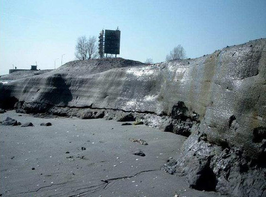
| G | Section G was excavated with a relatively steep slope because of insufficient space for a more gradual transition (similar to zone ABC). At start of the monitoring this area was a non-embanked sandy mudflat. In the more upstream part of the G section a steep cliff, with a height between 0.3 and 1.5m developed over a length of 100m (Figure 3 ) (Van den Bergh 2005, Van den Neucker et al. 2007). |
Analysis of the evolution after restoration fits in with the decisions about the Development outline 2010 and Long Term Vision 2030 (Dutch and Flemish agreement on integrating accessibility, naturalness and flood safety) and the updated Sigmaplan (Flemish plan for flood protection combined with ecological objectives), of the Dutch and Flemish governments, that committed them to leap forward with the ecological rehabilitation of the Scheldt estuary. An important challenge is the creation of tidal wetlands by transformation of woods or agricultural land into tidal mudflats and marshes. In order to assess the feasibility and to identify possible problems any similar small scale projects already in place, such as Ketenisse, are studied in detail to improve our apprehension of the larger scale future plans.