Disclaimer:
The authors are solely responsible for the content of this report. Material included herein does not represent the opinion of the European Community, and the European Community is not responsible for any use that might be made of it.
Back to overview measures
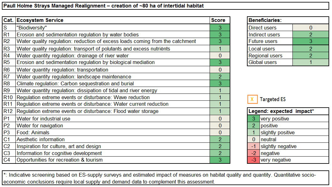
The key objective of this measure was to create intertidal habitat to compensate for direct losses associated with flood defence schemes as well as coastal squeeze. This is linked with ecosystem services ‘flood water storage’ and ‘dissipation of tidal and river energy’ as well as ‘biodiversity‘. It also provides ‘opportunities for recreation and tourism’ through becoming a tourist and bird watching attraction.
Table 2: Targeted ecosystem services
Step 2: Involved habitats
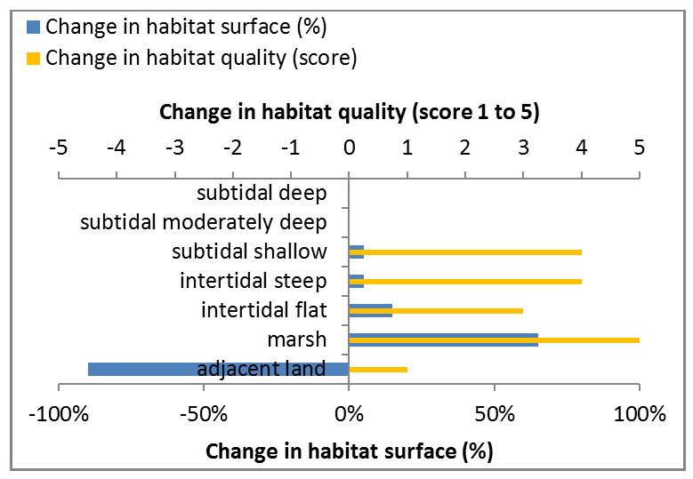
Intertidal mudflat and saltmarsh were created as a result of this measure.
Table 3: Ecosystem services analysis for Paull Holme Strays: Indication of habitat surface and quality change, i.e. situation before versus after measure implementation
The measure Paull Holme Strays Managed Realignment in the polyhaline zone of the Humber estuary was about the creation of intertidal habitat by transforming adjacent land into mainly marshland with a very high change in the habitat quality.
From the ES assessment it is concluded that this measure generates overall a positive expected impact for many ES, mainly for:
Back to top
Paull Holme Strays Managed Realignment
Table of content
- 1. Measure description
- 1a. Measure description
- 1b. Monitoring
- 1c. Monitoring results
- 2. Execution of main effectiveness criteria
- 2a. Effectiveness according to development targets of measure
- 2b. Impact on ecosystem services
- 2c. Degree of synergistic effects and conflicts according to uses
- 3. Additional evaluation criteria in view of EU environmental law
- 3a. Degree of synergistic effects and conflicts according to WFD aims
- 3b. Degree of synergistic effects according to Natura 2000 aims
- 4. Crux of the matter
- 5. Literature
Impact on ecosystem services
Step 1: Targeted ecosystem servicesThe key objective of this measure was to create intertidal habitat to compensate for direct losses associated with flood defence schemes as well as coastal squeeze. This is linked with ecosystem services ‘flood water storage’ and ‘dissipation of tidal and river energy’ as well as ‘biodiversity‘. It also provides ‘opportunities for recreation and tourism’ through becoming a tourist and bird watching attraction.
Table 2: Targeted ecosystem services
| Measure | |
| Food: animals | |
| Water for industrial use | |
| Water for navigation | |
| Climate regulation: carbon sequestration | X |
| Regulation extreme events or disturbance: flood water storage | X |
| Regulation extreme events or disturbance: water current reduction | |
| Regulation extreme events or disturbance: Wave reduction | |
| Water quantity regulation: drainage of river water | |
| Water quantity regulation: dissipation of tidal and river energy | X |
| Water quantity regulation: landscape maintenance | |
| Water quantity regulation: transportation | |
| Water quality regulation: transport of pollutants and excess nutrients | |
| Water quality regulation: reduction of excess loads coming from the catchment | |
| Erosion and sedimentation regulation by water bodies | |
| Erosion and sedimentation regulation by biological mediation | |
| "Biodiversity" | X |
| Aesthetic information | |
| Opportunities for recreation & tourism | X |
| Inspiration for culture, art and design | |
| Information for cognitive development | |
Step 2: Involved habitats
Intertidal mudflat and saltmarsh were created as a result of this measure.
Table 3: Ecosystem services analysis for Paull Holme Strays: Indication of habitat surface and quality change, i.e. situation before versus after measure implementation
| MEASURE | before | After | |||
| surface (%) | Quality (1-5) | surface (%) | quality (1-5) | ||
| Marsh habitat | above mean high water, floods at spring tide |
0 | 0 | 65 | 5 |
| Intertidal steep habitat | floods every tide, mainly steep zones at marsh edges |
0 | 0 | 5 | 4 |
| Intertidal flat habitat | floods every tide, flat zones | 0 | 0 | 15 | 3 |
| Subtidal shallow habitat | never surfaces, less deep than 2m | 0 | 0 | 5 | 4 |
| Subtidal moderately deep habitat | never surfaces, 2m-5m | 0 | 0 | 0 | 0 |
| Subtidal deep habitat | never surfaces, deeper than 5m | 0 | 0 | 0 | 0 |
| ADJACENT LAND | NON FLOODED LAND | 100 | 4 | 10 | 3 |
| 100 | 100 | ||||
| Quality |
| 1 = very high quality |
| 2 = high quality |
| 3 = medium quality |
| 4 = low quality |
| 5 = very low quality |
The measure Paull Holme Strays Managed Realignment in the polyhaline zone of the Humber estuary was about the creation of intertidal habitat by transforming adjacent land into mainly marshland with a very high change in the habitat quality.
From the ES assessment it is concluded that this measure generates overall a positive expected impact for many ES, mainly for:
- “biodiversity”
- Cultural service: Opportunities for recreation and tourism
- Some regulating services: Erosion and sedimentation regulation (by water bodies); Water quality regulation: reduction of excess loads coming from the catchment; Erosion and sedimentation regulation by biological mediation; Climate regulation: Carbon sequestration and burial.