

Disclaimer:
The authors are solely responsible for the content of this report. Material included herein does not represent the opinion of the European Community, and the European Community is not responsible for any use that might be made of it.
Back to overview measures
Following data collection, the general approach to the analysis has been to compare the physical and biological properties of the developing habitat (i.e. the realignment site) with those of the natural habitat (i.e. outside the realignment site) (e.g. Evans et al., 1998; Garbutt et al. 2006; Marquiegui & Aguirrezabalaga, 2009, Franco & Mazik, 2011 and previous, referenced monitoring reports). However, this broad approach does not account for spatial heterogeneity in terms of habitat development and colonisation within created habitats and therefore does not allow a detailed understanding of site development. More recently the monitoring has aimed to assess the spatial and temporal distribution of invertebrates, vegetation and birds in relation to elevation and other physical factors. The relationships between the physical and biological parameters have been examined in order to determine the factors governing colonisation by plants and invertebrates and use of the site by birds.
The deep creek that formed outside the southern breach cut back through the breach in 2006. It joined up with the field drain crossing the site and cut back up the drain, deepening it considerably during 2007-8. Most of the shallow pool at the southern end of the site was draining between tides in 2008 around the back and into the field drain, and the other shallow pool half way down the southern strip now drains into the confluence of two field drains and out through the southern breach.
Since the first measurements in May 2004 (to September 2010), the level of the mudflat surface in the northern sector has built up between 4.96cm at the highest site at the base of the northern hill, to almost three quarters of a metre (73.0cm) at the lowest site. The mean value for total accretion for all sites in the northern sector between May 2004 and September 2010 was 38.9cm. All sites in the northern sector have continued to accrete sediment each year. There has been a progressive decrease of net accretion rate over time, particularly at the low-lying sites which have been accreting most rapidly. This is expected as the general surface elevation increases (and therefore duration of tidal inundation decreases).
In the first five years of monitoring, accretion was measured in spring and early autumn, and a significant seasonal pattern in accretion was shown, with greater net accretion occurring over the winter periods than during the summer, when there was a levelling off in rates. This was evident at all sites except for some of the highest sites in the southern sector where there was also no clear decline in accretion rate over time because rates were low from fewer tidal inundations.
The southern sector of the realignment site lies at a higher elevation than most of the northern sector and accretion has continued to be much lower than in the northern sector, as would be expected. The mean value for total accretion at all sites in the southern sector between May 2004 and September 2010 was 7.63cm (range 1.12-22.1cm).
Estimated total accretion from the time of breach to September 2010 gave the highest level of accretion at the lowest site of approximately 92cm, and the lowest level at the highest site of 1.5cm. The estimated mean total accretion from the time of breach to September 2010 was 46.5cm for the northern sector and 8.8cm for the southern sector.
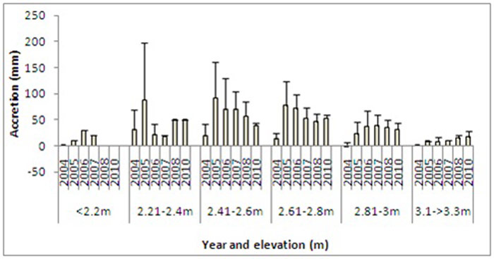
Mean total accretion values were also calculated for sites grouped into six elevation categories because accretion is highly dependent on elevation. Elevations measured in 2007/2008 with an RTK GPS were adjusted to give the elevations for 2004 and 2010 from the accretion before and after the RTK GPS measurements were taken. In general, there has been a trend of increase in elevation, as a result of accretion, throughout the area with elevation increasing from 2.2-2.42 m and 2.46-2.6 m at stations on the foreshore between 2004 and 2010. However, accretion rates and the subsequent increase in elevation has been much more rapid inside the realignment site. Annual accretion values range from almost 0 to 30 mm at <2.2 m and 18-88 mm at 2.21-2.4 m (Figure 10). Maximum accretion occurred at 2.41-2.6 and 2.61-2.8 m (up to 91 mm in any one year) although the rate in both sectors has decreased over time.
Accretion on the developing marsh above ≈2.8mODN was shown to be comparable to rates outside the managed realignment site, but higher at lower elevations. Although accretion rates have been decreasing as the elevations have increased at lower sites, the mudflat area has built up at a much faster rate inside the realignment site compared with open mudflat outside. Sediment accretion has been much greater (2-3 times) at elevations below ≈ 2.8mODN inside the realignment.
The high rate of accretion is thought to be due to the degree of shelter and the upper shore location of realignment sites and has been recorded from similarly sheltered areas in the middle region of the Humber (Mazik, 2004; Boyes & Allen, 2007). This is likely to be due to lower wave energy and possibly longer residence time of water, due to protection from the remaining sea wall. However this has not been formally tested.
Whilst all of the measured physical parameters appear to have some degree of influence over the invertebrate communities and the degree of colonisation by vegetation, elevation and accretion were consistently the most important explanatory variables in all years for the site. This was demonstrated by both univariate and multivariate techniques. In particular, M. balthica, S. shrubsolii, P. elegans, nematodes and several oligochaete species were negatively correlated with elevation and positively correlated with accretion. The correlation between these species and accretion is interesting since the relationship between elevation and accretion is different inside and outside the realignment site. This may be due to the fact that the site is in a state of continual development but also because of the degree of shelter and the flooding and draining patterns which differ to those on the foreshore. However, it is thought that the positive correlation between these invertebrates and accretion is due to the significant level of colonisation in the muddy area of the north western part of the realignment site. The benthic communities in this area are now representative of those on the foreshore (Mazik et al., 2010).
Vegetation has continued to spread across the site and has increased in cover density. It has increased in diversity at lower elevations where low- mid- marsh species have filled in and behind what was previously pioneer vegetation. Species diversity has decreased in some higher areas where perennial grasses such as Puccinellia maritima have become very dense, and tall grasses at upper elevations such as Elytrigia sp. have achieved very dense cover, shading out shorter-lived and smaller species.
The dominant species in the lower zones on and around the mudflat is Spartina anglica, particularly in the northern parts of the site (the annual pioneers Salicornia europaea and Suaeda maritima are more prominent in the southern part). The perennial grass Puccinellia maritima is dominant at mid-elevations and very dense (up to 99% cover in places), particularly in the southern part of the site. The highest areas close to the outer embankment between the breaches, the transition zone around the northern hill, and the higher parts of the drain edges, are covered with dense Elytrigia atherica (with some Elytrigia repens, and occasional patches of Festuca rubra and Agrostis stolonifera). Large patches of Phragmites australis and some Scirpus maritimus are found across the site (areas where there is some brackish water influence).
All of the salt marsh halophyte species and salt tolerant glycophytes found on the salt marsh outside the realignment were found inside the site by 2007 (24 species), with the exception of Limonium vulgare which is very rare in the Humber Estuary and had not been noted inside the realignment site by September 2010. Additional salt tolerant plants present outside the realignment site up to the driftline, have been found in the realignment site, making over 30 species of halophytes and salt–tolerant glycophytes.
In 2010 the species mix inside the realignment according to elevation was not very different from that outside, but there were still differences in cover abundance of many species, except at the lowest vegetation elevations where Spartina anglica was dominant. Some of the major species outside above 2.6mODN are now abundant inside, particularly Puccinellia maritima, but Atriplex portulacoides for example is common outside but was slow to come into the realignment site and is still rare inside. Some species that are more common inside above 2.6mODN are remnants of early colonisers of the bare ground, such as Atriplex prostrata, Spergularia marina and Puccinellia distans which have been in rapid decline since typical perennial salt marsh grasses such as Puccinellia maritima and Elytrigia atherica have increased in cover. It may take a few more years before the realignment site reaches a close match in community composition and abundance to the salt marsh outside at the same elevations.
Vegetation density and the distribution of saltmarsh species were also strongly related to elevation. MDS and Simper analysis (based on data collected in September, 2010 (Brown, 2011) indicated a dominance of S. anglica at the lower elevation (with no vegetation at the lowest elevations) and an increase in species diversity with increasing elevation. The dominant species at the higher elevations (>3.01 m) included P. maritima and A. tripolium and, above 3.2m, A. prostrata, E. atherica and S. media.
Back to top
Paull Holme Strays Managed Realignment
Table of content
- 1. Measure description
- 1a. Measure description
- 1b. Monitoring
- 1c. Monitoring results
- 2. Execution of main effectiveness criteria
- 2a. Effectiveness according to development targets of measure
- 2b. Impact on ecosystem services
- 2c. Degree of synergistic effects and conflicts according to uses
- 3. Additional evaluation criteria in view of EU environmental law
- 3a. Degree of synergistic effects and conflicts according to WFD aims
- 3b. Degree of synergistic effects according to Natura 2000 aims
- 4. Crux of the matter
- 5. Literature
Monitoring results
The monitoring programme has been designed to determine the rate of accretion and saltmarsh development within the site, together with colonisation by benthic invertebrates (commenced September, 2004), physical development of the habitat (sedimentological properties) and use of the site by birds for feeding and roosting. These studies were carried out independently. Following the first five years of monitoring, it was apparent that the habitats and communities within the site were still in an early stage of development and the monitoring programme was extended to 2013 in order to fully assess whether or not the site would meet its objectives. Additionally, it was agreed that integrated analysis of the full data set was necessary to better understand the development process.Following data collection, the general approach to the analysis has been to compare the physical and biological properties of the developing habitat (i.e. the realignment site) with those of the natural habitat (i.e. outside the realignment site) (e.g. Evans et al., 1998; Garbutt et al. 2006; Marquiegui & Aguirrezabalaga, 2009, Franco & Mazik, 2011 and previous, referenced monitoring reports). However, this broad approach does not account for spatial heterogeneity in terms of habitat development and colonisation within created habitats and therefore does not allow a detailed understanding of site development. More recently the monitoring has aimed to assess the spatial and temporal distribution of invertebrates, vegetation and birds in relation to elevation and other physical factors. The relationships between the physical and biological parameters have been examined in order to determine the factors governing colonisation by plants and invertebrates and use of the site by birds.
Accretion
The Paull Holme Strays realignment site comprises a wider northern section and a narrower southern strip. Since the site was breached sediment accretion has built up large areas of the mudflat to an elevation suitable for salt marsh development and this accretion process will continue. The shallow pools in the northern sector (present after the breach) drained after the first year or so and the vegetation that initially colonised the drier site margins below the embankments and the edges of the drains crossing the site has continued to spread out onto the mudflat. Salt marsh vegetation has also spread out from the drain edge that marks the southeastern boundary of the northern sector. Drainage creeks have developed across the mudflat which has become drier and firmer and the Spartina anglica (Common Cord-grass) which began to colonise parts of the central mudflat after about 2005 has continued to spread and join up to form extensive patches of continuous vegetation.The deep creek that formed outside the southern breach cut back through the breach in 2006. It joined up with the field drain crossing the site and cut back up the drain, deepening it considerably during 2007-8. Most of the shallow pool at the southern end of the site was draining between tides in 2008 around the back and into the field drain, and the other shallow pool half way down the southern strip now drains into the confluence of two field drains and out through the southern breach.
Since the first measurements in May 2004 (to September 2010), the level of the mudflat surface in the northern sector has built up between 4.96cm at the highest site at the base of the northern hill, to almost three quarters of a metre (73.0cm) at the lowest site. The mean value for total accretion for all sites in the northern sector between May 2004 and September 2010 was 38.9cm. All sites in the northern sector have continued to accrete sediment each year. There has been a progressive decrease of net accretion rate over time, particularly at the low-lying sites which have been accreting most rapidly. This is expected as the general surface elevation increases (and therefore duration of tidal inundation decreases).
In the first five years of monitoring, accretion was measured in spring and early autumn, and a significant seasonal pattern in accretion was shown, with greater net accretion occurring over the winter periods than during the summer, when there was a levelling off in rates. This was evident at all sites except for some of the highest sites in the southern sector where there was also no clear decline in accretion rate over time because rates were low from fewer tidal inundations.
The southern sector of the realignment site lies at a higher elevation than most of the northern sector and accretion has continued to be much lower than in the northern sector, as would be expected. The mean value for total accretion at all sites in the southern sector between May 2004 and September 2010 was 7.63cm (range 1.12-22.1cm).
Estimated total accretion from the time of breach to September 2010 gave the highest level of accretion at the lowest site of approximately 92cm, and the lowest level at the highest site of 1.5cm. The estimated mean total accretion from the time of breach to September 2010 was 46.5cm for the northern sector and 8.8cm for the southern sector.
Mean total accretion values were also calculated for sites grouped into six elevation categories because accretion is highly dependent on elevation. Elevations measured in 2007/2008 with an RTK GPS were adjusted to give the elevations for 2004 and 2010 from the accretion before and after the RTK GPS measurements were taken. In general, there has been a trend of increase in elevation, as a result of accretion, throughout the area with elevation increasing from 2.2-2.42 m and 2.46-2.6 m at stations on the foreshore between 2004 and 2010. However, accretion rates and the subsequent increase in elevation has been much more rapid inside the realignment site. Annual accretion values range from almost 0 to 30 mm at <2.2 m and 18-88 mm at 2.21-2.4 m (Figure 10). Maximum accretion occurred at 2.41-2.6 and 2.61-2.8 m (up to 91 mm in any one year) although the rate in both sectors has decreased over time.
Accretion on the developing marsh above ≈2.8mODN was shown to be comparable to rates outside the managed realignment site, but higher at lower elevations. Although accretion rates have been decreasing as the elevations have increased at lower sites, the mudflat area has built up at a much faster rate inside the realignment site compared with open mudflat outside. Sediment accretion has been much greater (2-3 times) at elevations below ≈ 2.8mODN inside the realignment.
The high rate of accretion is thought to be due to the degree of shelter and the upper shore location of realignment sites and has been recorded from similarly sheltered areas in the middle region of the Humber (Mazik, 2004; Boyes & Allen, 2007). This is likely to be due to lower wave energy and possibly longer residence time of water, due to protection from the remaining sea wall. However this has not been formally tested.
Benthic Invertebrates
The distribution of invertebrates on mudflats is governed by a variety of factors including immersion, sediment particle size, organic content, sediment porosity, drainage and consolidation, redox potential and other chemical factors, adult and larval dispersal ability and competitive and trophic interactions (Little, 2000). Many of these factors are strongly related to tidal elevation and wave energy. Hence, finer sediments tend to be present at higher elevations on intertidal mudflats and are associated with a higher organic content and, often lower oxygen content. It is therefore not surprising that the distribution of invertebrate species was strongly influenced by elevation.Whilst all of the measured physical parameters appear to have some degree of influence over the invertebrate communities and the degree of colonisation by vegetation, elevation and accretion were consistently the most important explanatory variables in all years for the site. This was demonstrated by both univariate and multivariate techniques. In particular, M. balthica, S. shrubsolii, P. elegans, nematodes and several oligochaete species were negatively correlated with elevation and positively correlated with accretion. The correlation between these species and accretion is interesting since the relationship between elevation and accretion is different inside and outside the realignment site. This may be due to the fact that the site is in a state of continual development but also because of the degree of shelter and the flooding and draining patterns which differ to those on the foreshore. However, it is thought that the positive correlation between these invertebrates and accretion is due to the significant level of colonisation in the muddy area of the north western part of the realignment site. The benthic communities in this area are now representative of those on the foreshore (Mazik et al., 2010).
Vegetation
Most of the narrower southern sector of the realignment site was initially at an elevation suitable for salt marsh establishment (except for areas with permanent shallow water bodies), and salt marsh vegetation has established and increased in density and diversity except in waterlogged areas.Vegetation has continued to spread across the site and has increased in cover density. It has increased in diversity at lower elevations where low- mid- marsh species have filled in and behind what was previously pioneer vegetation. Species diversity has decreased in some higher areas where perennial grasses such as Puccinellia maritima have become very dense, and tall grasses at upper elevations such as Elytrigia sp. have achieved very dense cover, shading out shorter-lived and smaller species.
The dominant species in the lower zones on and around the mudflat is Spartina anglica, particularly in the northern parts of the site (the annual pioneers Salicornia europaea and Suaeda maritima are more prominent in the southern part). The perennial grass Puccinellia maritima is dominant at mid-elevations and very dense (up to 99% cover in places), particularly in the southern part of the site. The highest areas close to the outer embankment between the breaches, the transition zone around the northern hill, and the higher parts of the drain edges, are covered with dense Elytrigia atherica (with some Elytrigia repens, and occasional patches of Festuca rubra and Agrostis stolonifera). Large patches of Phragmites australis and some Scirpus maritimus are found across the site (areas where there is some brackish water influence).
All of the salt marsh halophyte species and salt tolerant glycophytes found on the salt marsh outside the realignment were found inside the site by 2007 (24 species), with the exception of Limonium vulgare which is very rare in the Humber Estuary and had not been noted inside the realignment site by September 2010. Additional salt tolerant plants present outside the realignment site up to the driftline, have been found in the realignment site, making over 30 species of halophytes and salt–tolerant glycophytes.
In 2010 the species mix inside the realignment according to elevation was not very different from that outside, but there were still differences in cover abundance of many species, except at the lowest vegetation elevations where Spartina anglica was dominant. Some of the major species outside above 2.6mODN are now abundant inside, particularly Puccinellia maritima, but Atriplex portulacoides for example is common outside but was slow to come into the realignment site and is still rare inside. Some species that are more common inside above 2.6mODN are remnants of early colonisers of the bare ground, such as Atriplex prostrata, Spergularia marina and Puccinellia distans which have been in rapid decline since typical perennial salt marsh grasses such as Puccinellia maritima and Elytrigia atherica have increased in cover. It may take a few more years before the realignment site reaches a close match in community composition and abundance to the salt marsh outside at the same elevations.
Vegetation density and the distribution of saltmarsh species were also strongly related to elevation. MDS and Simper analysis (based on data collected in September, 2010 (Brown, 2011) indicated a dominance of S. anglica at the lower elevation (with no vegetation at the lowest elevations) and an increase in species diversity with increasing elevation. The dominant species at the higher elevations (>3.01 m) included P. maritima and A. tripolium and, above 3.2m, A. prostrata, E. atherica and S. media.